March 28, 2011

Trekking in Escalante Country - Adventures on Slick Rock


A year-and-a-half ago, we went out to an area of remote slickrock in the Escalante area of Southern Utah. Linda was so impressed with the region that she vowed to return and go deeper into that landscape. So, after Hilina and I headed back to Sedona from Big Water, Linda and Kathleen headed off to Escalante. They packed in their gear to go camping off in the wilderness.


After hiking amongst barren slick rock ridges and sandy draws, the girls found just the perfect spot to set up for the night. It was chilly up there at 6,000 feet, but luckily the expected snow and rain held back.


This landscape is made up of Navajo Sandstone, which were formed by ancient sand dunes some 180 million years ago in one of the largest and most long-lasting deserts in Earth's history. The sand dunes likely piled up over 2,000 deep in places and partially form the landscapes that are most familiar to most visitors to the Southern Utah, including Zion Canyon, Arches and Canyonlands National Parks.


All along the slick rock were numerous waterpockets and tinajas. A waterpocket is a depression in the rocks that holds rainwater. Some of these waterpockets can hold water for a few weeks and are home to specialized crustaceans such as Triops that go through their entire lifecycle in just a few weeks before laying dessicating-resistant eggs that can lay in the dried mud for years, sometimes decades, before hatching the next time the pool fills. Due to their light weight, the eggs often blow in the winds when the pools dry to find other pools to colonize. Since these eggs can last up to 27 years, even if they do not land in a pool immediately, they will have more chances over time.


A tinaja is a larger pool in the bedrock that is more permanent in nature. They tend to be fed by springs or seepage and due to their depth are more shaded from the intense summer sun by the surrounding rocks. Tinajas are not only critical sources of water for wildlife in an arid desert, but provide homes for numerous aquatic species such as frogs/toads, crustaceans, and even occassionally at some Sonoran desert sites, desert pupfish.

Some tinaja are so well established, that riparian vegetation and even trees get established along their banks


All across the landscape are large boulders of volcanic materials that seem completely out of place. These lava rocks come from layers that were laid well down above this layer (the surface of Boulder Mountain at above 10,000 feet). How did these lava rocks get all the way down here? Well, as the soft sandstone eroded away over time, the more resistant lava rocks rode the dropping elevations down, remaining on the surface.


Linda and Kathleen's goal was to reach the confluence of two rivers. But, as perhaps should have been expected, upon reaching the edge of the river, a narrow slot canyon was encountered. So, while they could skirt the edge of the canyon, there was no going down there.


On of the fascinating features you find in sandstone formations, especially those formed by fossilized sand dunes, are concretions called "moqui balls". These concretions form when iron oxide and other minerals precipitate out of solution from ground water when conditions dry out.


After three days out in Escalante country, they trekked out in advance of an impending winter storm. The day after they returned to Sedona, a huge snowstorm arrived dropping 1/2" of snow in Sedona and several inches in Flagstaff. But, what an adventure.


March 25, 2011

Trekking to the edge of Paria Canyon, Utah


Last week, when we were away from the blog, we did a trip back up to the old stomping grounds of Southern Utah. Our friend Kathleen (from the Egypt Series Fame) was visiting and we wanted to show her the amazing features of the Grand Staircase-Escalante National Monument. We tried to take her out to the spectacular Buckskin Gulch-Cobra Arch area, but the road was washed out. So, instead we drove out across the landscape until we were about 1.5 miles from the edge of the Paria Canyon and then headed out on foot.


When you are going across rugged terrain, one of the best ways to get there is often following washes and drainages. That CAN be the best way. But, sometimes you end up arriving at cliffs and dry waterfalls that are impassable and you need to come up with a new plan.


Upon arriving at the edge of the Paria Canyon, you notice that the cliffs are a couple of hundred feet high and the water is always a milky/muddy brown in the river. This is just a couple of miles downstream from the official trail access point near US-89. In the image above, you can make out the official trail on the far side of the river.


Further down the canyon, it is a different story, where the drop is measured in the thousands of feet! But, that is for another post.

Trekking in Grand Staircase-Escalante is an amazing experience because it is 1.9 million acres of mostly unroaded wildlands. Yes, you will see cows grazing in many areas and ATV tracks across the landscape. But, it also means you can wander, without trails, for miles. Trails are not necessary due to the open landscape, but orienteering skills and/or a GPS are valuable since you will be dropping into ravines, washes, and around hills and need to find you way back.


It also helps to have a sense of humor and be prepared to butt-scoot down steep slickrock slopes.

March 23, 2011

Final Days in Egypt


After Luxor, we took the night train back up to Cairo. We were picked up and were off the Museum of Egyptian Antiquities in downtown Cairo. And, when the news was made last month with the protests of Tahrir Square, the images were very familiar to us. The reason was that this museum sits right there at Tahrir Square. This site is very symbolic to the Egyptians and during our stay hundreds of Sudanese refugees were protesting and being hit by water cannons after protesting the lack of support by the Egyptian government to their cause. This happened to occur the night after our visit to the museum and foreigners who then advised not to go downtown.


As far as the museum is concerned, cameras were strictly prohibited, so I do not have any photos from inside. There certainly are some impressive artifacts, including mummies, sarcophagi, statues and votives, coins, and papyri. Unfortunately, I felt like the museum was not well planned and many of the artifacts seemed out of place and out of context. It would have been nice to have put them into some sort of reconstruction of what the sites would have looked like to see how these tombs were originally built.


Afterwards, it was off to the Great Bazaar for lunch and some exploring of the little shops in every nook and cranny. Although I was disappointed, as I have mentioned earlier, that we were not given any real authentic Egyptian food during the trip, the one thing I really enjoyed was the mint tea.


The Great Bazaar was actually built during the rule of the Ottoman Empire in 1382 in the classic Turkish style. It was here I bought a little chess set. There were some really beautiful Arabic/Islamic style artwork I would not have minded getting, but my cash flow was running low at that point. 


Around the bazaar and actually across much of Cairo, the mosques have Turkish-style minarets. These towers are skinny and round, as opposed to old fat and square towers of the earlier Egyptian-style prior to the Ottoman takeover. Back in the day, the call to prayers was done by a man singing from the top of the minaret. Today, it is done by loud speakers of previously recorded calls.


Finally, it was back to our hotel for the final night. In the morning, the skies were overcast. But, as we took off to the north and over the vast Nile Delta, we did get a glimpse of the bread-basket of the Arab world. This vast flat expanse of green is covered by farmland and scattered villages.


The Nile once snaked its way across the entire 150 mi width and 100 mile length of the delta in many different channels. But, today it is all channeled into two branches. In addition, since the Nile no longer floods since the building of the High Aswan Dam, the coastline is eroding at 50 km per year and the silt is being depleted by agriculture with no new influxes. To make up for that, they now have to rely on fertilizers and pesticides. But, they are having problems with rising sea levels and subsidence (remember the Louisiana Coast posts?).


One thing that is amazing to imagine is, that 5.5 million years ago, during the Messian Salinity Crisis, that the Mediterranean Sea was almost completely dried up (The Straits of Gibraltar were blocked and it evaporated) and the Nile carved a 8,000 foot deep canyon where Cairo is now to get to the lower sea bed. Thus, in the 5.5 million years since the Mediterranean refilled, the Nile sediments have filled that entire canyon and built the massive delta. Wonder what will happen now that the silt no longer flows?

March 22, 2011

Medinet Habu in Ancient Thebes


Medinet Habu is the mortuary temple of Ramesses III. Ramesses III was Pharoah around 1180-1150 BC and ruled for 31 years. During this time, Egypt was constantly under assault by the "Sea People's", a confederation of tribes, mostly from the area of modern day Israel and Lebanon, as well as, from Libya and Sardinia, trying to establish control of the eastern Mediterranean.


Many of the reliefs on the walls of this temple are dedicated to Ramesses III's battles to fight off these invasions. While he was mostly successful in warding them off, the battles so drained the Egyptian economy that it began the steady decline of the Egyptian power base.

This relief shows the Pharoah showing no mercy on "Sea People" invaders

It is known that Egypt suffered a major setback at around year 29 of Ramesses III reign due to an extended drought and poor growing conditions. This led to an emptying of the grain stores and a major workers strike. Recent evidence now shows that perhaps the Hekla 3 eruption in Iceland at that same time put up so much ash into the air that growing conditions declined worldwide.

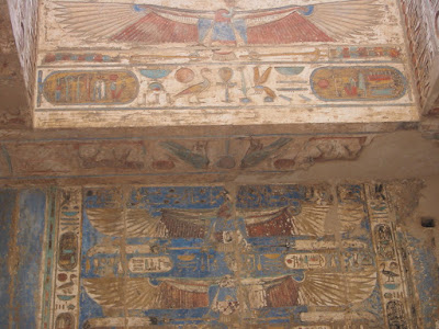
Ceilings tend to have the most surviving paint in the temples because they are most protected from winds and rain

Egypt would never be the same. Their international influence would be weakened dramatically, for which they would never recover, as they soon lost control of most of their colonies in West Asia.


While the Pharoahs would continue to rule Egypt proper for another 400 years, it is interesting that a volcanic eruption thousands of miles away may have been the straw that broke the camel's back of the massive power of the Egyptian empire that had lasted for thousands of years.

March 21, 2011

Karnak Complex and Luxor Temple in Ancient Thebes


The Karnak Complex is the largest ancient religious site in the world. This sprawling complex of temples, columns, and ruins was built by Ramesses II around 1350-1390 BC. This complex was built in honor of the Theban Triad, let by the head honcho god Amun.

Two rows of sphinxes greet you as you enter the front "door"

Karnak is really huge and you could grow exhausted just walking through all of its various little niches and chambers. But, there are some amazing sites within it you can not miss.


There are at least two well preserved obelisks within the temple. While quite a number of Egyptian obelisks were transported around the world during the colonial era, if you see one in London, Paris, Rome, or New York, you will see that most of the engravings have faded away from the corosive effects of acid rain and pollution. Not so here in this dry climate. They look like they were carved 100 years ago, not 3500!


Min, my buddy and the namesake of our tour company. You have got to respect a God so willing to put it all out there for the public to see. Unlike most Neolithic and older cultures whose fertility gods are buxom females, in Egypt fertility was clearly all about the male package down below.


There are numerous reliefs about various battles, trade missions, and events in Egyptian history. Here you can see a line up of Nubian women (From Sudan/Ethiopia) coming to pay their respects. Or, perhaps they were slaves captured from numerous raids and wars down south. Who knows, I am not an Egyptologist.

One of the most amazing parts of Karnak Temple is the Great Hypostyle Hall. This giant complex, whose roof has collapsed, was held up by 134 absolutely massive columns that were 33 feet in circumference and 80 feet high. They are really packed close together, so it is difficult to capture the site with a camera. Due to how close together the columns are, this would not have exactly been a spaceous building to spread out in. It is amazing how much work it was to put something like this together.

Nearly all columns in Egypt are built in the style of the papyrus plant

Papyrus was a very important plant to the Ancient Egyptians. It, of course, was made into paper and scrolls of papyrus that survived thousands of years in this dry climate. These papyri have been critical to understanding the history of the ancient world. In addition, parts of papyrus can be eaten and it was used to build boats and baskets.


Luxor Temple was built around 1400 BC and is located in modern day downtown Luxor. It was also dedicated to the Theban Triad led by Amun. Luxor and Karnak were major places of celebration during the annual Opet Festival, which celebrated the flooding of the Nile in late summer (from monsoons in the Ethiopian Highlands) and the fertility brought to the soils for agriculture brought by the silt.


During the festival, cult statues of Amun, Khonsu, and Mut were paraded down the Avenue of Sphinxes that connected the two temples in a celebration for the life-giving waters and sediment of the Nile floods. The Pharoah and other dignitaries would recieve the statues, conduct religious ceremonies, and then take off by boat down the river to return to Karnak.


After the New Kingdom declined and other forces began to control Egypt in the later period, Luxor Temple was used for a number of purposes.

A relief showing the plowing of the soil following the annual Nile floods

Ptolemaic (Greek) rules converted a number of the buildings for their use and then the Romans came in and covered a number of the walls with frescoes similar to those seen in Pompeii.

A Roman fresco on a wall within Luxor Temple

Later, early Christians converted many temples in Egypt into churches and then in the 7th century mosques were built in many of the temples as well. Oh well, I guess it is just a way of recycling. The good news for us in the modern era is that at least this procession of peoples left these monuments intact enough for archeologists and historians to study and for visitors to explore and learn about our ancient past. Unfortunately there are so many places and sites where people did not consider the cultural past and simply dismantled or destroyed ancient sites for their own purposes. But, for the most part in Egypt, they have tried to preserve their ancient past, despite the difficulties of being a poor nation.

A mineret of a mosque within Luxor Temple

March 20, 2011

Tombs of the Nobles and Forced Hospitality at Thebes


One of the most beautiful sites we visited in all of Egypt were the Tombs of the Nobles. This was not actually a part of our original tour package, but was offered to us as a "bonus" for $150 by our Luxor guide. Our Luxor guide was not a Min employee, but an independent guide contracted out by Min to take care of us while down there. I'll have more on him below.


The tombs are actually located directly underneath the village of Sheikh Abd el-Qurna. This ramshackle town of mud and thatch huts with donkeys in the "yards" was not what I expected at such an amazing archeological site. I am surprised the Egyptian authorities would allow it, as it would seem to threaten the very stability of the site. All around were various folks sitting around wanting to offer their services "for a fee".


But, inside what a treasure. These were the tombs of nobles, including local government officials and skilled tradesmen and artists that actually built and decorated the great temples and tombs of the Pharoahs. They carved out their own burial sites and saved their best artwork for themselves. The "guides" wanted us to pay them for the right to take photos. It wasn't so much to "preserve" the site as it was for them to get a little extra cash in their pockets. So I had to discretely take a couple of images without them noticing. But, suffice it to say, the best preserved and most vibrant paintings of all of Egypt were in these tombs. I wish I had seen more of these tombs.


There are actually quite a number of these kind of brightly decorated tombs all around the entire Luxor area. But, these were the ones we could see on this particular tour. Anyways, our Luxor guide was not very good. He did not explain things very well (unlike Mohammed or our Coptic guide) and was not very interested in answering our questions with any depth. He sort of just dragged us around, uncaring about our interests or health (Kathleen had another bout of Pharoah's revenge and Linda and I weren't 100% either). But, he was mostly just interested in directing us to his friends and brother's various businesses, whether it be for lunch or shopping or whatever, rather than the sites and history of the area.

Getting lunch on Day 1 in Luxor at a "friend's" restaurant

I think he started to get the message by day two that we were getting kind of annoyed with him. That's when he insisted, and I mean insisted, that we get a "free" sugar cane drink at a friend's cafe. We declined, but he drove us there anyways. When we arrived, we watched his friend "wash" our glasses out with just the straight tap water (no soap) in a dirty open aire kiosk and then just grab some stalks of dusty sugar cane from a pile that looked like they were straight from the field and put them into a large juicing machine. The sugar cane juice just went straight into these glasses. It wasn't very sanitary and we were not eager drink it. But, we felt obliged by this forced hospitality. We had already had stomach ailments earlier in the trip, and after 10 days in Egypt we sort of just figured we had nothing to lose at this point. He had worn us down with his "hospitality". Luckily, we survived the ordeal without any further illness.

A sugar cane field in the Nile Valley

But, OK I'll admit it, the sugar cane drink did taste good!

March 18, 2011

Parque El Torcal de Antequera, Andalucia, Spain


Located in south-central Andalucia, just north of Malaga, is a spectacular karst landscape called El Torcal. This park is filled with spectacular columns, fins, and canyons carved out of 150-million year old Jurassic limestone. You can access Parque El Torcal by taking the A45 autovia north from Malaga to Antequera. Look for signs for the village of Villanueva de la Concepción and then a paved road climbs up to the parking area near the ridgetop.


The layers were laid down during a period when a shallow seaway formed between the Atlantic and Tethys seas during the Jurassic period. During the Tertiary Period, the area was uplifted into a plateau. Millions of years of rain and freeze-thaw wedging (especially during the ice ages) has left a rugged landscape almost devoid of soil. But, because of its harshness, it has been spared intensive human interference. Thus, it is actually home to some rare and endangered species including Spanish Ibex, Griffon vultures, and two endemic snake species.


Because of the intense heat of the Spanish summers, as well as, the exposed rocks that absorb the suns rays, avoid this area in mid-summer. Also, be careful in winter for ice that may cover the trails in shady canyons.

A view across the Andalucian landscape from the edge of El Torcal

There are a number of trails that cross through this beautiful landscape that range from short easy 1.5 km loops to longer more strenuous hikes across the entire area. Check with the visitor center to find the one that fits your needs and activity level.


If you take one of the longer loops, you drop into some shady canyons where the vegetation is suddenly much denser and lusher. The canyons not only provide additional shade and thus maintain more moisture, but also protect dust and soil from being blown away. So, the soils are slightly thicker and there are oaks and other trees ekeing out a living there.

As you work your way from pinnacle to canyon, be careful not to grab the rocks with your hands too much. Some of them are razor sharp, as the dissassociation of the limestone by the slightly acidic rainwater forms sharp fins and edges.


The horizontal layers are clearly evident throughout the areas. Some are thick and others thin. These different layers allow for the formation of columns and hoodoos, some of which collapse, while others form flat-topped toadstools.


So, if you are ever in Andalucia to check out the famous Alhambra in Granada, the great cathedral in Sevilla, or the tiny colony of Gibraltar, you should swing an hour north of Malaga to see the amazing Parque El Torcal.