May 31, 2010

Gros Ventre Wilderness, Wyoming


From Dinosaur National Monument, we camped at Flaming Gorge National Recreation Area, which was far from impressive. So, the next day we cruised north into Wyoming and straight up toward Jackson Hole and Grand Teton National Park.

Bridger-Teton National Forest in Western Wyoming


We camped in the national forest area just above Jackson Hole with spectacular views across the valley to the Teton Mountains. This was one of the best campsites we'd been at in the entire trip. It was dispersed camping on soft grass, it was free, and the views were excellent. From there, we did a lovely day hike in the Gros Ventre Wilderness to the near alpine Goodwin Lake.

The Gros Ventre Mountains from the campsite at dusk

There were some really nice mountain meadows full of wildflowers in the early part of the hike. At this elevation, Ponderosa pines still dominate, with plentiful balsam roots in bloom. Later, we entered a forest of aspen and Engelmann spruce at higher elevations near 10,000 feet.

White Columbines

Several miles in I saw what appeared to be a gray wolf flash across the trail. I can't be sure since it was so fast. Maybe it was a large gray coyote. But, this is wolf country and at these elevations, that seems to be the more likely scenario. Nonetheless, neither Maile or Linda seemed to notice, so who knows.

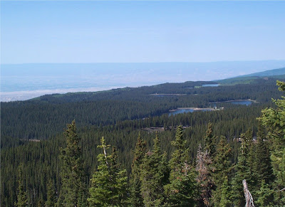
Here we've arrived at Goodwin Lake. It was heavily forests along the shores, so this was the only place I could get a good view across to the talus slopes on the otherside.

Here, Linda relaxing back at the campsite at dusk

May 30, 2010

Dinosaur National Monument, CO/UT


After leaving Steamboat Springs, we cruised across the sage-scrub prairies of Northwastern Colorado on the way to Dinosaur National Monument.


Along the way, we encountered millions of bugs crossing the road. As the density got thicker and thicker, we decided to stop and figure out what they were. It turns out they were Mormon Crickets. A weird looking insect to say the least.

Mormon Cricket

Dinosaur National Monument consists of two primary units. The first we visited still within Colorado is the deep canyon where the Green and Yampa Rivers meet. This region had been designated a national monument in the early 1900's due to the plentiful amounts of dinosaur bones found in the formations.


But, in the 1950's there was a movement to build a dam on the Green River and flood the two conjoining canyons to form the Echo Park Dam and Reservoir. This created a major outcry across the country in one of the first major moves of the modern environmental movement. The Sierra Club sponsored a rafting trip down the rivers in the canyons and filmed the adventure and then distrubuted the film to all members of congress and the public. Soon thereafter, the canyons were protected forever against empoundment.

Here you can see the tilted layers of sediment with horizontal layers on top.

The view east along the escarpment

From the cliffs and canyon area, we continued west into Northeastern Utah to the town of Vernal and to the Quarry Area, where the dinosaur bones have been found in the highest concentrations. The rocks here are sandstones and siltstones of the Morrison Formation that formed in a lowland area of slow-flowing rivers and marshes. The thick accumulation of dinosaur bones occurs as they died and sank into the muddy sediments.

Ever present thunderstorms of the Rockies here at the Visitor Center

The visitor center has a wall of rock inside that was excavated to reach the bones, but left in-situ to see the actually bones in their original positions.

Bones of Allosaurs and numerous other species have been found here

A thigh bone of a dinosaur embedded in the original rock

The Morrison Formation is highly tilted and deformed by the uplift of the nearby Uinta Mountains

Here Linda stands next to a leg of large herbivorous dinosaur

May 29, 2010

Rocky Mountain National Park, Colorado


From Boulder, we headed up to Estes Park and then across into Rocky Mountain National Park. Unfortunately, the combination of deep snow above 12,000 feet and constant thunderstorms, forced us to make this mostly a drive through experience.


One of the most interesting aspects of the park is the treeline ecology. At about 12,000 feet in elevation, the trees suddenly stop. Unlike the Pacific Northwest, where treeline is controlled by the depth of the snowpack, the Rocky Mountain treeline is formed where temperatures drop below -40F in the winter. At that critical temperature, the sap in the phloem freezes, expanding and tearing the vessels open and making it impossible for those trees to survive. That seems to be one of the key ecological features of treelines in many mountains on Earth and at the Arctic Circle.


In addition, you will notice that the valley bottoms are also devoid of trees. That occurs where cold air sinks down from the mountains in winter and settled into the valley bottom. These freezing temperatures also kill the trees down there. But, the middle elevations between 9,000 and 12,000 feet stay just warm enough to continue to support an Engelmann Spruce/Subalpine fir forest. In addition, herbivores like Rocky Mountain Elk also trim back seedlings, keeping the meadows open for grazing.


The Rockies are somewhat frustrating in summer, with the constant daily thunderstorms preventing us from hiking at the higher elevations. Here you can see them rolling in even before noon.

All our grand plans of hiking a 14'er or so were being crushed day after day by these storms. We were basically being forced to stay below 10,000 feet.

Here you can see a creek meandering through the meadow-covered valleys

Given the weather, we simply did a short hike up the headwaters of the Colorado River toward its source, in and amongst aspens, cottonwoods, and firs.  It did begin to rain on us after about an hour, so eventually we turned back. He headed out the west entrance and then off to Steamboat Springs, where we stayed overnight. We ate dinner that night at an excellent Italian restaurant.

May 27, 2010

Crossing the Rockies from Grand Junction to Boulder


We decided to cross the Rockies again and head over to see Denver and Boulder. We could have just jumped on I-70 for a straight shot. But, instead we decided to take the scenic route and take a few days. We had planned to do some hikes, but the combination of thick snow, thunderstorms, and Linda's allergies made it difficult at that time.

The mountains near Aspen

We first went to Aspen and walked amongst fancy boutiques and wealthy ski resorts. That was certainly an interesting and unexpected experience. But, we determined we couldn't possibly afford to stay overnight in that town. So, we headed out into the outskirts and camped in the nearby White River NF.

Setting up camp


We found this absolutely beautiful aspen-covered campground that remains one of my favorite places to tent camp I ever did. From there we headed out on CO-82 over the 12,000 foot Independence Pass, one of the highest in North America.

Independence Pass

This highway then descends down a dizzying array of switchbacks and takes you to the base of Mount 14,433 foot Mount Elbert, the highest peak in the Rocky Mountains and 2nd highest in the lower-48 (and just 22 feet higher than Mount Rainier).

Mount Elbert and the Twin Peaks

Mount Elbert from Twin Lakes

There it was off to Leadville, at 10,150 feet, the highest town in North America. We stayed overnight at a historic hotel in town and enjoyed the nice coffee shops in its historic district. It was formerly a mining town, but has been trying to change its image. It was really chilly in the morning, and being July, it gave us insight about how cold it must be to live there.


From there it was off to Boulder and the home of the University of Colorado. But, first we had to go over 11,300 foot Fremont Pass. Anyways, Boulder is a beautiful town, with pedestrian areas in the shopping districts, and an almost European feel. The University of Colorado has a nice campus too. If they want to join the Pac-10, I wouldn't be against it.


May 26, 2010

Colorado National Monument, Colorado


Seems like a fairly redundant name, doesn't it? We hadn't even heard of the place until we arrived in Grand Junction. The Colorado National Monument is located at the northeastern edge of the canyon country just about 20 miles west of Grand Junction. We'd seen this landscape from Grand Mesa and decided to head over and check it out.


It certainly is a beautiful place. But, coming from Big Water, UT in the heart of the Colorado Plateau as we were, it felt a little redundant to us as well. We'd come to Colorado to see the mighty Rockies, not more sandstone cliffs.


So, we pretty much zoomed through the place as a day trip. We probably did not give the place the attention it deserved. But, we also were laid off by our employer and was trying to find out if they were going to bring us back. So, we ended up spending two fruitless days in Grand Junction on the cell phone trying to get word of what was happening. So, we were a bit distracted to truly enjoy this spectacular place.


Maybe we'll go back someday and soak it in the way it deserves.

May 25, 2010

Grand Mesa National Forest, Colorado


To the west of the Black Canyon of the Gunnison and near Grand Junction is the largest of the mesas of the Colorado Plateau and in fact in the world. The 11,000+ foot high Grand Mesa is a landscape of sedimentary rock that was preserved from erosion by a volcanic cap of basalt. It sits between the Colorado River and the Gunnison River. This 11,000 foot flat-topped plateau stand thousands of feet above the surrounding landscape. It is more than 6000 feet higher than nearby Grand Junction.

Driving up the talus covered Grand Mesa with the basalt cap clearly visible above.


Because of the 10 million year old basalt cap on its summit, there are numerous mountain lakes that are unable to drain into the more porous sedimentary rock below it. Much of the mesa is flat, but areas were volcanic dikes erupted leave a linear ridgeline that tops out at 11,237 Crater Peak.


We decided to hike that volcanic summit ridge and get an unparalleled panoramic view of the region from the top. From the Grand Mesa, the multi-colored hues of the sedimentary rocks of the Colorado Plateau are clearly visible, including the Colorado National Monument west of Grand Junction.

The volcanic ridgeline above the mesa is called Crags Crest

Colorado National Monument across the Grand Valley from Crags Crest

Of course, when you are up at 11,000 feet in Colorado, you are approaching treeline and there are some very beautiful mountain meadows full of wildflowers mixed in and amongst the spruce and aspen forests.

Linda and Maile arriving at the summit


Some 300 mountain lakes dot the Grand Mesa

It was certainly a very chilly night camping at 11,000 feet, so we did not stay the extra day we'd planned to do another hike up there. Rather, we toured a little bit up there and then headed down to Grand Junction to get a hotel room, a shower, pizza, and a movie.